![](/images/other/stat-length.png)
![Trail Walking Quebec City - Montmorency Falls Park - Photo](https://media.geolcdn.com/t/1900/400/ext.pjpeg?maxdim=2&url=https%3A%2F%2Fstatic1.geolcdn.com%2Fsiteimages%2Fupload%2Ffiles%2F1553511878bg_sport_marche.png)
Montmorency Falls Park
Alizée.pee
User GUIDE
![Length](/images/other/stat-length.png)
Length
4.4 km
![Max alt](https://static1.geolcdn.com/siteimages/upload/files/1508320355ic_sort_altitude_max_24dp.png)
Max alt
105 m
![Uphill gradient](https://static1.geolcdn.com/siteimages/upload/files/1508320355ic_sort_den_pos_24dp.png)
Uphill gradient
136 m
![Km-Effort](/images/other/stat-length.png)
Km-Effort
6.2 km
![Min alt](https://static1.geolcdn.com/siteimages/upload/files/1508320355ic_sort_altitude_min_24dp.png)
Min alt
3 m
![Downhill gradient](https://static1.geolcdn.com/siteimages/upload/files/1508320355ic_sort_den_neg_24dp.png)
Downhill gradient
136 m
![Boucle](https://static1.geolcdn.com/siteimages/upload/files/16400158638029165_repeat_loop_refresh_sync_direction_icon.png)
Boucle
Yes
Creation date :
2019-09-05 10:02:21.452
Updated on :
2019-09-05 10:03:12.19
![Walking](https://static1.geolcdn.com/sitytour/trail-icons/101.png)
2h00
Difficulty : Medium
![Scan this QR Code to open this trail in the SityTrail application](https://capi.geolives.com/qq0zvz2zws4bq2lad0pu/sitytour/trails/2192208/qr.png?size=200)
FREE GPS app for hiking
About
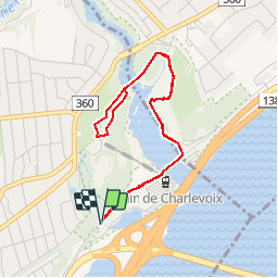
Trail Walking of 4.4 km to be discovered at Quebec, Québec (Agglomération), Quebec City. This trail is proposed by Alizée.pee.
Description
Cette randonnée est très jolie. Le sentier passe par une cascade et est considéré comme sentier de niveau moyen. Le sentier offre de nombreuses activités tout au long de l’année et les chiens y sont autorisés. Le paysage offert par cette randonnée est juste incroyable.
Positioning
Country:
Canada
Region :
Quebec
Department/Province :
Québec (Agglomération)
Municipality :
Quebec City
Location:
Beauport
Start:(Dec)
Start:(UTM)
336173 ; 5194426 (19T) N.
Comments
Trails nearby
![Trail Walking Quebec City - Chutes de Montmorency - Photo](https://media.geolcdn.com/t/375/260/ext.jpg?maxdim=2&url=https%3A%2F%2Fstatic1.geolcdn.com%2Fsiteimages%2Fupload%2Ffiles%2F1553511878bg_sport_marche.png)
![Walking Walking](https://static1.geolcdn.com/sitytour/trail-icons/101.png)
Chutes de Montmorency
Walking
Medium
Quebec City,
Quebec,
Québec (Agglomération),
Canada
![](/images/other/stat-length.png)
6.7 km | 8.9 km-effort
1h 45min
![](https://static1.geolcdn.com/siteimages/upload/files/16400158638029165_repeat_loop_refresh_sync_direction_icon.png)
Yes
![Trail Walking Saint-Pierre-de-l'Île-d'Orléans - St-Pierre-de-l'Île-d'Orléans Marche à pied - Photo](https://media.geolcdn.com/t/375/260/ext.jpg?maxdim=2&url=https%3A%2F%2Fstatic1.geolcdn.com%2Fsiteimages%2Fupload%2Ffiles%2F1553511878bg_sport_marche.png)
![Walking Walking](https://static1.geolcdn.com/sitytour/trail-icons/101.png)
St-Pierre-de-l'Île-d'Orléans Marche à pied
Walking
Very easy
Saint-Pierre-de-l'Île-d'Orléans,
Quebec,
L'Ïle-d'Orléans,
Canada
![](/images/other/stat-length.png)
4.3 km | 5.4 km-effort
1h 9min
![](https://static1.geolcdn.com/siteimages/upload/files/16400158638029165_repeat_loop_refresh_sync_direction_icon.png)
No